CAMELBACK MOUNTAIN
strenuous hike in Phoenix
CAMELBACK MOUNTAIN
strenuous hike in Phoenix
 Location: Northeast Phoenix
Distance: about 2.4 miles round trip
Ascent: 1.264 feet to the summit
Hike time: about 1.5 hours roundtrip
Opening hours: daily from dawn to dusk
Direction: The Camelback Mountain is located east of 44th Street and
north of Camelback Road in Phoenix. To get to the Echo Canyon Park
Trailhead drive south on Tatum Blvd or north on 44th St, then east on
McDonald Drive and turn south onto Echo Canyon Parkway which leads to
the parking area (dead end) of the trailhead.
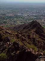
General information. Camelback Mountain is a prominent landmark and the
highest peak (2,704 feet) in the Phoenix Mountains. There are two trails
leading to the summit. The most popular is the 'Camelback Mountain Trail'
(from Echo Canyon Park TH) which is described on this page. The other
one is the 'Cholla Trail' (from Cholla Ln).
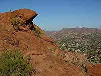 Geology. It is interesting that the 'camel’s head' consists of layered
rock sediments (sandstones) of Tertiary age (70 - 100 million years old)
but the 'hump of the camel' is composed of Precambrian granite (1.5 billion
years old), uplifted 60 million years ago.
Geology. It is interesting that the 'camel’s head' consists of layered
rock sediments (sandstones) of Tertiary age (70 - 100 million years old)
but the 'hump of the camel' is composed of Precambrian granite (1.5 billion
years old), uplifted 60 million years ago.
CAMELBACK MOUNTAIN TRAIL (from Echo
Canyon Park TH)
The hike. This is a very popular trail with some beautiful sandstone
rock formations along the trail. Be careful there are some steep
drop-offs close to the trail and at the summit.
The hike starts at the parking lot (elevation 1,440 feet) and ramada and
follows the well-signed trail. Soon you cross a wash and then the trail ascends.
You will pass a huge rock which is used for rock-climbing practice)
and a trail junction which gives access to a ramada on your right.
Don’t turn there, go straight up the trail.
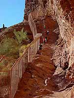
After about 0.3 miles you will reach a fence. The trail goes between
the fence (on your left) and an overhanging cliff wall (on your right).
Here you have a nice view down to beautiful homes in Paradise Valley.
Then the trail becomes steep over slippery rock for some time.
Use the hand-rail. After about 0.5 miles the trail levels briefly
and offers another great view point. From here on the trail is
(mostly) steep, partially straight up or meanders back and forth
between rocks.
At 0.75 miles two routes diverge. You can take either one -
heading uphill about southeast. At 1.0 miles the trail turns first east
then northeast towards the summit. Soon you will reach the peak
(elevation 2,704 feet) with a 360 panoramic view.

Summary. The trail length is about 1.2 miles but mostly
steep and strenuous. Most first time hikers of this trail underestimate
the difficulty because of the short distance.
Tipps: Smaller steps are easier to control and also easier on your knees. Don't
hike too fast - especially if you are not used to the desert climate and the
heat.
Note: You hike at your own risk. Information found on this site is not
guaranteed to be correct. Please be aware that you are in the desert.
Wear appropriate clothing and shoes and bring plenty of water.
During my hike there was a rescue mission by helicopter
on the way for a hiker with some problems. Unfortunately this
does happen very often on Camelback Mountain.
Website Orientation:
> Home/Welcome
> EXTRA!!! my magazine
> Trips & Hiking
> Hiking in the greater Phoenix area
> Camelback Mountain (= you are here)
[Welcome]
[USA Austria]
[EXTRA - my magazine]
[Webcam Links]
[Link Collection]
[About me]
[Photo Collections]
[Downloads]
[Disclaimer]
[Sitemap]
[Guestbook]
[Email]

 If you didn't get to this page through the mainpage ('choose a language')
of gbintheworld.com
then please click here!!!
© gbintheworld