back to previous page WATERHOLES CANYON the challenge

Waterholes Canyon
Waterholes Canyon
Location: just a few miles south of Page, crossing US-89, Navajo Indian Reservation, Arizona
Distance: 270 miles from Phoenix, 7 miles from Page
Opening hours: no restrictions
Fees/Permit: yes, Navajo tribal fee, hiking permit (see details farther down on this page)
Direction: from Page drive south (towards Flagstaff) on US-89 for about 7 miles to the bridge over the Waterholes Canyon (bridge sign on the road); park on the northeast side of the bridge (at the gate) near Mile Marker 542.

Waterholes Canyon. It is another interesting slot canyon in the Page area. Cutting through the Navajo sandstone on both sides of a main street (AZ-89) it provides beautiful rock formations in a great variety of colors.

About the name: The sunlight does not hit the canyon floor at many spots because of the direction of the canyon and the most narrow and deep sections of it. So the remaining water of flash floods in small but sometimes deep puddles (waterholes) evaporates slowly.
There are two ways how the name of this canyon is written - Waterholes Canyon or Water Holes Canyon.
Tipp: If you search on the net for info about this canyon use both variations to collect all available websites.

It is common that the Waterholes Canyon is 'devided' in descriptions into the upper or upstream section (part) and the lower or downstream section though the canyon is not split in two parts by nature. The 'deviding point' is the bridge of the AZ-89 over the canyon. So the upstream section is located east of the bridge, the downstream section west of it (towards the Colorado River).

US-89 bridge
On the main access trail into the canyon; view at the US-89 bridge crossing the canyon
Access into the canyon. There are several ways (access points) into the canyon. The main access is through the gate at the parking area. Behind the gate you walk a few steps southeast and will find a trail heading down into the canyon. This is the easiest way.
If the gate is locked (if Navajos are not present the gate is most of the time closed but not locked) you can choose. You might hike cross-country eastwards (on the northern side of the canyon rim) till you find an easy way down into the canyon (upstream section) or you cross the road and immediately access the canyon (from the north side) on a small and steep trail (downstream section).

The visit. I walked through the gate and the few steps to the rim. There I found the trail heading down into the canyon (see also the photo on the right). At the canyon floor I went first upstream (east) and soon walked through some nice narrows, connected by a few wider sections of the canyon with less steep walls where the sun has a chance to get to the canyon floor.

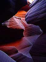
A wider part of the upstream section
In this upstream part you will find small side canyons which are worth to explore.
After about 45 minutes of enjoying the eastern slots I turned around and went back. Close to the bridge I passed the main access trail and went farther west, climbed over an old car wrack (under the bridge) down into the downstream section (just below the wreck you can exit the canyon on a steep trail up to the bridge).

Now I got into the deeper canyon with many beautiful sandstone formations, typical for slot canyons in the southwest. Every few hundred feet I had to climb down drops which were not higher than 6 or 7 feet. A challenge I didn't mind even there was a water pond almost every time below a drop. Sometimes you can pass the muddy water on slippery ground if the water does not stretch from wall to wall - at two spots I used some 'chimney technique' where the canyon was narrow enough. Once I didn't have a choice and soaked my hiking boots.
On my way deeper into the downstream section I kept an eye on a few spots where the canyon walls 'offered' a chance to exit this slot canyon by climbing out - just in case...

view from above
View from above at the lower, most western part towards Glen Canyon / Colorado River
I knew that I would get to a point where a canyon drop would be to deep to get down without a rope. And after about an hour in the western section I was standing at the edge of a 25 - 30 feet steep drop. That was the end of my hike. I had to turn around and went back to the last wider part of the canyon. There I explored the chances of getting out and with some scrambling I made it back out to the northern rim (see photo on the right).

Here a look around showed me that I had made it about half the way to the Glen Canyon and the Colorado River. For a moment I thought about hiking on the surface to the Glen Canyon rim but I decided to go back to the parked car near the bridge. It had been already an interesting challenge - enough for that day.

The permit. The Waterholes Canyon is located on Navajo land. You need a permit for hiking there.
There are two ways to get a permit:
If there are Navajos at the gate (parking area) they will offer you a guided tour which includes the permit (Navajo Tribal fee). If they are not present at the time of your visit or you decide to access the canyon at other points you will have to get a hiking permit ahead at the Navajo Parks & Recreation Office, about 3 miles south of Page on US-89, phone (928) 698-3272.
FYI: You need a permit for all hiking tours on Navajo land.

The map. The best map for the Waterholes Canyon is the USGS Lees Ferry Quad (see also the link to Waterholescanyon Map on the bottom of the page).

All photos: © by gbintheworld.com

Waterholes Canyon
Waterholes Canyon,
upstream section
wreck below the bridge
Waterholes Canyon,
wreck below the bridge
Waterholes Canyon
Waterholes Canyon
downstream section

Summary. The best about the Waterholes Canyon is its diversity - a slot canyon with many faces. There the less experienced hiker and the slot canyon enthusiast can find interesting spots.

The upstream and easier part (east of the bridge) contains very nice narrows and wider canyon parts. The first part of the downstream and more difficult section (west of the bridge) shows almost one long narrow with a few easy drops to climb. The second section (closer to the Colorado River) leads to high and steep drops for which ropes are necessary.

Water Holes Canyon
Waterholes Canyon (enlargeable),
downstream section
Water Holes Canyon
Waterholes Canyon (enlargeable),
downstream section

This slot canyon does not provide the concentrated package of stunning formations compared to the Antelope Canyons but it is a must for all friends of slot canyons because of its diversity (formations, changes of light and color), steepness, length and different difficulties in various areas.
Another benefit: The Waterholes Canyon is less famous - so there are by far less visitors as in other slot canyons in this region.

Warning! Don't enter any slot canyons if there is the slightest chance of rain in the area that might trigger a dangerous flash flood.
Be aware that you might encounter rattle snakes in this canyon. Watch your steps and were you put your hands if climbing. During my hike in the upstream section I had the chance to say 'Hi' to one of these reptiles.

Source: my experience at the canyon
All information: as of fall 2003

Nearby attractions:
Please visit
Trips and Sightseeing in northern Arizona for other interesting parks, monuments and places north of Phoenix or Hiking in northern Arizona for more of my tours.

Links to websites and infos about the Waterholes Canyon and Page (links open in a new window):
Water Holes Canyon info & photos @ americansouthwest.net E
Waterholes Canyon photos by Amy Jordan E
Canyoneering - Waterholes Canyon photos by John Hart E
Waterholes Canyon Map & GPS online info provided by topozone.com E
Waterholes Canyon @ lalasreisen.de D
Page official website of the city E


[BACK]

send to printer


Website Orientation:
> Home/Welcome
  > EXTRA!!! my magazine
    > Trips & Hiking
      > Trips and Sightseeing, Northern Arizona
      > Hiking, Northern Arizona
        > Waterholes Canyon (= you are here)

[Welcome]  [USA Austria]  [EXTRA - my magazine]  [Webcam Links]  [Link Collection]
[About me]  [Photo Collections]  [Downloads]  [Disclaimer]  [Sitemap]  [Guestbook]  [Email]


back to top back to previous page Home - www.gbintheworld.com If you didn't get to this page through the mainpage ('choose a language')
of gbintheworld.com then please click here!!!

© gbintheworld


Datenschutzerklärung