Here you will find some basic information about the trailheads for the
Coyote Buttes North and South area and the 'main road' to them.
For detailed information (distances, tipps, photos,...) visit the Coyote Buttes
pages Trailheads North Area (for
The Wave) and
Trailheads South Area.
One thing have both areas in common:
To get to the trailheads you have to use the House Rock Valley Road
which goes south from the US-89, the road between Page (AZ) and Kanab (UT).
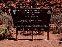
Wire Pass TH,
main access point for
hikes to The Wave
The marked trailheads (or TH) and parking areas on the House Rock Valley Road
are called (in order as you drive south):
Buckskin Gulch TH
Access point to the slotcanyon Buckskin Gulch and farther to the
Paria Canyon which do not belong to the Coyote Buttes area but you
will pass the TH on your way to the
Wire Pass TH
Access point to the Coyote Buttes North (The Wave) and Wire Pass Trail
(Paria Canyon area).
Notch TH
Access point to the Coyote Buttes North (The Wave).
The following trailheads are used to get into the Coyote Buttes South.
They are located east of the House Rock Valley Road.
Lone Tree TH
Access point to the southwest area of the Coyote Buttes South. It is
the last non-4WD access point.
Paw Hole TH
Also a trailhead to the southwest area of the Coyote Buttes South.
Cottonwood Cove TH
The best access point to the beautiful Cottonwood area.
Cottonwood Spring TH
Even a little bit closer than the C.C. TH but this part of the road is
in terrible condition.
HOUSE ROCK VALLEY ROAD (BLM Rd. #700)
It is a north-south connection dirt road between US-89 (Page/AZ - Kanab/UT) and
US-89A and also the main access road to the trailheads of the Coyote Buttes.
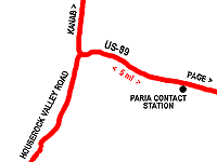
The easiest way to find the dirt road (House Rock Valley Road, BLM Rd. #700)
which leads to trailheads is to drive the US-89 from the Paria
Contact Station (mile marker 21) west for 5 miles. There the street makes a
turn to the right and the access to the road you are looking for
is on the left side. It becomes a dirt road right away and you will pass
a flashflood warning sign after 0.2 miles.
Note: You will have to cross several deep ditches (washes). The road conditions
change dramatically in or after rain. In that case driving (even for 4WDs)
will become extremely difficult if not impossible. Rangers do not suggest
to drive that road with RVs in any road condition - but I have seen
smaller RVs at the Wire Pass TH.
 It is a north-south connection dirt road between US-89 (Page/AZ - Kanab/UT) and
US-89A and also the main access road to the trailheads of the Coyote Buttes.
It is a north-south connection dirt road between US-89 (Page/AZ - Kanab/UT) and
US-89A and also the main access road to the trailheads of the Coyote Buttes.