|
COYOTE BUTTES SOUTH TRAILHEADS After you passed the Wire Pass TH (8.2 miles from the US-89) you keep going south, cross the border from Utah to Arizona (sign) and pass The Notch TH (10.4 miles) too. In good weather this dirt road is still easy to use even with 'normal' cars - though you have to cross some washes. At 14.2 miles you get to an intersection. There the Winter Road goes to the right - you keep going to the left. After almost another 2 miles you have to leave the House Rock Valley Road and make a left turn (16 miles) to the east into the dirt road that brings you to the Lone Tree Reservoir after a few hundred yards - the tree is easy to see. |
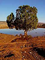 LONE TREE TRAILHEAD
To be honest this is actually not a trailhead. It is more the last parking area for 'regular cars' - from here on the Lower Paw Hole Road is strictly for high clearance 4WDs. If you don't use an off-road vehicle you will have to park here and hike 2.5 miles to the Paw Hole TH - the first 'real' trailhead for the Coyote Buttes South. Note: If you can not pass the Lone Tree TH because of flooding you can make a detour around it. It is longer to drive but the detour (only for high clearance 4WDs) will bring you to the Poverty Flat Ranch on another road and close to the Cottonwood area. Details further down on this page. From the Lone Tree TH it is another 2.5 miles to the next trailhead and parking area. |
|
|
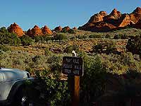 PAW HOLE TRAILHEAD
The Paw Hole TH is easy to find (there is a wooden sign) and is located close to the Paw Hole Teepees (left photo). According to a Ranger this area is supposed to be easy to hike and he suggested to explore the western part of the teepees. I have not done any hiking there because I wanted to get closer to the beautiful Cottonwood area - so I stopped only for a photo and then kept driving. Note: If it was difficult for you to drive to this trailhead you might not go further. From here on the road becomes very deep and sandy. Now the 'fun' part for off-road fans begins. Areas with sand and deep tracks in combination with some sharp turns and a road that heads here for the most time uphill let you stay focused on how and where to drive. On this part of the road I made two mistakes (once I used the wrong gear and speed and the other time I hit the brakes to hard). Both situations let me do some exercise - I had to use a shovel to get the Jeep out of deep sand. Tipp: It might be a good idea to check out upcoming sand areas before you drive through, level deeper holes or fill up very deep tracks. Don't drive to slow through sand areas, keep the speed going, stop only on rocky terrain. 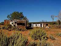 If you keep driving you will get to a turn-off (to the left) after
about 3 miles. Make a left and the road (BLM Rd. #1066) will
bring you to the Cottonwood Cove TH.
If you keep driving you will get to a turn-off (to the left) after
about 3 miles. Make a left and the road (BLM Rd. #1066) will
bring you to the Cottonwood Cove TH.At this intersection you can see a windmill in the distance. It belongs to the abandoned Poverty Flat Ranch (right photo). Stop there for a minute or two - you deserve a short break. Ok, then go back to the intersection and use the BLM Rd. #1066 which runs north. This road is very sandy too but it is mostly even - at least for the first part when you drive along an airfield for smaller planes. Soon you will see that there is another road a few feet away parallel heading the same direction (north). I used the one to the right because it seemed to be not so deep and sandy as the left one (road conditions can change very often, walk ahead and see for yourself which road is the easier to drive for you). Soon the road is going slightly downhill towards Cottonwood Cove. You might think easy to drive but keep in mind you will have to use the same road on your way back - and then it goes uphill in the sandy tracks. It is about 2 miles from the turn-off close to the Poverty Flat Ranch to the best access point into the Coyote Buttes South - the Cottonwood Cove TH. |
|
|
 COTTONWOOD COVE TRAILHEAD
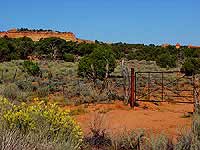
There is no sign at this trailhead but you will see a close-by corral and come to a stop at a gate (usually closed and secured with a chain) of a cattle fence. There you can park your car and look for the Cottonwood Teepees in the distance (northwest) - they are fairly close (photo on the left: some teepees are visible above the fence, the higher Cottonwood area is on the left side). It takes about 24 miles and 1.5 hours to drive from the beginning of the House Rock Valley Road (at US-89) to the Cottonwood Cove TH. In my opinion the Cottonwood Cove TH is the best access point for the Coyote Buttes South (at least for this part of it) but there is an even closer trailhead - the Cottonwood Spring TH. |
|
|
|
COTTONWOOD SPRING TRAILHEAD This trailhead is about 1.5 miles farther north but the road conditions are just terrible. Deep and wide holes and even deeper sand (compared to the road to the Cottonwood Cove TH) make it almost impossible to drive. Note: I hiked this road for about 1 mile on my way into the Cottonwood area. I would never drive it. |
|
|
|
DETOUR TO THE POVERTY FLAT RANCH (around the Lower Paw Hole Road) If it's not possible to pass the Lone Tree Reservoir because of flooding you might use the following detour: Drive for about 4 miles from the Lone Tree Reservoir south on the House Rock Valley Road. There make a left onto the BLM Rd. #1017 (east). After 3 miles you will come to the BLM Rd. #1066, make a left (north) and drive for another 6 miles to the Poverty Flat Ranch. Note: This detour is (as the direct and shorter road to the Poverty Flat Ranch) only for high clearance 4WD vehicles! |

| Datenschutzerklärung |