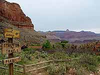
Begin from any viewpoint in the village or along Hermit Road. The Rim Trail
offers excellent walking for quiet views of the inner canyon and for visitors
who desire an easy hike.
view from the Rim Trail
Destination: Along the Village Rim
Distance (round trip): your choice
Approx. time (round trip): 15 min to 1.5 hours
Elevation change: up to 200 feet (60 m)
Notes: paved, easy walk, passes historic buildings.
Destination: Along Hermit Road
Distance (round trip): your choice
Approx. time (round trip): 15 min to all day
Elevation change: up to 200 feet (60 m)
Notes: becomes unmarked dirt path west of Maricopa Point.
BRIGHT ANGEL TRAIL (steep)
Trail begins just west of Bright Angel Lodge. Some shade, seasonal water (check
at the visitor center at Canyon View Information Plaza for status), upper
portion may be icy during the cold season (use crampons for safe walking).
3 Mile Resthouse
Indian Garden (enlargeable)
Destination: 1 1/2 Mile Resthouse
Distance (round trip): 3 miles / 4.8 km
Approx. time (round trip): 2-4 hours
Elevation change: 1131 feet (345 m)
Notes: restrooms.
Destination: 3 Mile Resthouse
Distance (round trip): 6 miles / 9.6 km
Approx. time (round trip): 4-6 hours
Elevation change: 2112 feet (644 m)
Notes: -
Destination: Indian Garden
Distance (round trip): 9.2 miles / 14.8 km
Approx. time (round trip): 6-9 hours
Elevation change: 3060 feet (933 m)
Notes: restrooms, water.
Destination: Plateau Point
Distance (round trip): 12.2 miles / 19.6 km
Approx. time (round trip): 8-12 hours
Elevation change: 3195 feet (974 m)
Notes: extremely strenous hike, no water past Indian Garden,
view of river 1.5 miles beyond Indian Garden.
SOUTH KAIBAB TRAIL (steep)
Trail begins south of Yaki Point on Yaki Point Road. Best views for a
relatively short hike. Steep trail, no water, little shade. Access trailhead
via shuttle bus. Upper portion may be icy during the cold season
(use crampons for safe walking).
Destination: Ooh Aah Point
Distance (round trip): 1.5 miles / 2.4 km
Approx. time (round trip): 1-2 hours
Elevation change: 780 feet (238 m)
Notes: no water, first view east.
at Skeleton Point (enlargeable)
Destination: Cedar Ridge
Distance (round trip): 3 miles / 4.8 km
Approx. time (round trip): 2-4 hours
Elevation change: 1140 feet (347 m)
Notes: toilet, no water, first hitching rail.
Destination: Skeleton Point
Distance (round trip): 6 miles / 10 km
Approx. time (round trip): 4-6 hours
Elevation change: 2040 feet (622 m)
Notes: no water, second hitching rail, first view of river.
GRANDVIEW TRAIL (very steep)
Unmaintained steep trail requires caution. Begins on canyon side of
retaining wall at Grandview Point on Desert View Drive (12 miles east of
village). Only for experienced desert hikers. Hiking boots recommended.
Upper portion may be icy during the cold season (use crampons for safe
walking).
Destination: Coconino Saddle
Distance (round trip): 1.5 miles / 2.4 km
Approx. time (round trip): 1-2 hours
Elevation change: 1120 feet (341 m)
Notes: no water, use extra caution along narrow sections.
Destination: Horseshoe Mesa
Distance (round trip): 6 miles / 9.6 km
Approx. time (round trip): 6-9 hours
Elevation change: 2600 feet (793 m)
Notes: toilet, no water, use extra caution along narrow sections.
HERMIT TRAIL (steep)
Unmaintained steep trail requires caution. Begins 500 feet west of Hermits
Rest. Water from springs must be treated before drinking. Only for experienced
desert hikers. Hiking boots recommended.
Destination: Waldron Basin
Distance (round trip): 3 miles / 4.8 km
Approx. time (round trip): 2-4 hours
Elevation change: 1600 feet (488 m)
Notes: no water.
Destination: Santa Maria Spring
Distance (round trip): 5 miles / 8 km
Approx. time (round trip): 5-8 hours
Elevation change: 1680 feet (512 m)
Notes: treat water.
Destination: Dripping Springs
Distance (round trip): 7 miles / 11 km
Approx. time (round trip): 6-9 hours
Elevation change: 1700 feet (519 m)
Notes: treat water, use extra caution along narrow sections.