back to previous page GRAND CANYON my hike

Day 1

Early Morning

It is not really my favorite thing to get up very early in the morning. After four hours of sleep my alarm clock woke me up at 2:00 am and to my surprise I was immediately ready to go. All I needed was a cup of coffee and a shower.

My friend arrived at 2:45 am. My gear was 'dumped' on the back seat and we started our adventure to the Grand Canyon.


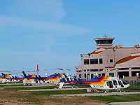
Helicopters at the Tusayan Airport (enlargeable)


Fireplace at the McDonald's in Tusayan, almost cabin-like

NOTE: Some photos here on this page can be enlarged for better viewing. Just click on a photo with the textline note 'enlargeable'. To get back to the previews page, click the 'Left-Arrow/Back Button' on the photo page or the 'Return Button' of your browser.

The Drive to the South Rim

At this day time the I-17 north from Phoenix to Flagstaff is a quiet highway and I made good progress behind the steering wheel while my partner tried to catch a little bit more sleep.

We made a stop at Denny's in Flagstaff for breakfast and at the gas station nearby to fill up the Jeep just after sunrise. It was now 5:00 am and we enjoyed the much cooler air in this higher country (Colorado Plateau). And an hour later we drove again, on Highway 180 north, passed the famous 'Museum of Northern Arizona' in Flagstaff and left the city soon behind us.

The Highway 180 is a beautiful drive, passing San Francisco Peaks (the highest mountain of Arizona, the upper part was still covered by snow in May) on its west side, through forests followed by a flat bush area. We turned right (north) at the intersection with AZ-64. I made a stop in Tusayan to take a picture of the helicopters at the airport and to use the bathroom at McDonnald's (I have been there before. It is the most interesting 'McD' I have seen - inside it looks more like a cabin and has a fireplace). Now the Grand Canyon is only a few miles away.

At the entrance of the Grand Canyon National Park I showed the Park Ranger my National Parks Pass (see also my page
Permits/Fees) and asked for directions to the Backcountry Office where we arrived just after 8:00 am.

At the Backcountry Office

It was already a busy place so we had to pick a 'serving number' and wait. Many other hikers were waiting with questions and asking for a permit to hike into the canyon.
Finally we were next, asking for a permit for the Bright Angel Campground. It was not our day. All permits for the next two days were given out. Knowing that you can get a permit for camping in the wilderness (off the corridor trails) I ask for one for the area of the Clear Creek Trail (section AK9, east of the Bright Angel CG). I had read about this trail leading to a beautiful and lush place around a waterfall of the Clear Creek. It seemed to be the best idea and we got the permits and paid for them.

Back at the car we started the final packing and re-packing of our backpacks to even out the weight, filling up water and so on. The compression bag for my friend's sleeping bag was missing. No chance to get everything into the backbags. We had to buy one. So we decided to drive to the big store in the Grand Canyon Village. There we bought the bag and other 'handy things' we thought could be helpful. Well, we got the wrong size ... to make a long story short it took us till after 11:00 am to get everything done. Valuable time was gone.

Still in good spirit we used the convenient shuttle system from the Backcountry Office to the South Kaibab trailhead. After a short walk from the bus to the rim, the Grand Canyon in it's beauty was laying in front of us. It was now almost noon.

South Kaibab Trail

We started our hike immediately, knowing that it might take us 5-6 hours to the Bright Angel Campground and at least another hour to reach the area on the Clear Creek Trail for which we had the over-night permit. And it would be dark at around 7:30 pm.


View from the South Rim at the
South Kaibab trailhead (enlargeable)


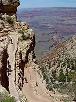
The first switchbacks

The trail started out with a number of switchbacks and descended fast into the canyon. We kept track of our time to make stops to rest and eat every 30 minutes, to drink plenty of water and to enjoy the beautiful views. This upper area is called Cedar Ridge, just above the O'Neill Butte, an impressive rock we would have to pass on the right on our way down to the Colorado River.

After several more switchbacks, a mule train coming out of the canyon was going to pass us. We moved to the inner side of the trail and followed the instructions of the head mule rider, "please stay on the inside, don't move, thank you". Well, not much else we could have done anyway but at least we knew we were doing it the right way.


Mule train


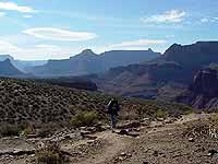
On my way into the canyon
(enlargeable)


Just a few hikers were on the trail with us. Some were faster hiking down with small backpacks, the ones coming up, making progress with short steps towards to the rim, were sweating, some of them with a red face but all of them with a friendly "How are you?" or "Are you ok?". We realized this was not just a way of saying 'Hi' - every hiker cares about the other here.

Approaching the O'Neill Butte, the trail followed a narrow ridge (to the left the wall went straight down for about 300 ft). Wow, that was all I could say.


Spring in the Grand Canyon,
blooming cacti (enlargeable)


First glimpse of the Colorado River
(enlargeable)


The O'Neill Butte right in front of us, the trail descended to the right - again in switchbacks, followed by an easier part of the trail towards Skeleton Point and for the first time we could see the Colorado River.


More switchbacks


The Natural Arch
Sharp right turn, step, step, step... sharp left turn, step, step, step... - and for the first time I detected that we were not talking as much anymore and my concentration was lacking. That was not a good sign! If you don't stay focused on your steps you can easily trip, spread an ankle or worse. I checked with my friend - same thing. We were getting tired and we were only half way down. The right time for another break - this time a little bit longer.

We felt better after eating and drinking, made jokes and laughted again. We went farther down the switchbacks, it was still a long way to go.

After a few minutes we met an older couple sitting in the shade of the rock wall. On their way up he had spread his ankle and had a hard time to stand. They told us that they had asked other hikers to inform the Park Rangers that they needed help. That was about 2.5 hours ago. Another hiker had already taken his backpack but even with less to carry it was not easy for him.
They had enough water so we promised to inform the Park Rangers again to make sure that help would come and continued our hike.

Reaching the bottom of the switchbacks and coming around a huge rock formation we saw a wider area, slightly descending and green, in front of us. What a beautiful view and nice change and we saw the famous Natural Arch, to the left of us.

Now I saw that my friend was not walking even, tried to shift the weight off the left foot - there was a big blister on the left big toe. To help a little bit I took my friend's sleeping-bag and attached it under my backpack. Every single pound less could help.

At that time we saw a woman coming up the trail, hiking in high-speed mode - a Park Ranger. She asked us about our condition and if we had seen someone who is waiting for help. We told her about the couple, their position and so on. Then she asked us for our permit. After knowing that we had to get to the Clear Creek Trail and my friend's big blister she meant that this would not be easy for us and it could be to late already. We might not make it before darkness to that trail.
She told us that we are very lucky because there is one last spot open at the Bright Angel Campground, changed our over-night permit with a pen and went on with long strides the way up the mountain to the waiting couple. Thank you, we shouted after her. We were happy!


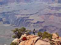
A beautiful view westwards...
(enlargeable)


...and eastwards from the same spot.
(enlargeable)


Even knowing that our final destination for the day was a little bit closer, our hiking progress was getting worse. My friend had a hard time walking with his backpack on his back. We took longer breaks and more often. Knowing that hiking for 10 minutes, followed by a 15 minute break, would not get us down to the Colorado in time. So I decided to take both backpacks, one on my back, the other one carrying in front of me. The result: It wore me out too. Now I needed the breaks and lots of water.

The lack of sleep slowed us finally down and the late start of our hike did not really help either - mistakes do add up! It was about 7:15 pm and we had less than one mile to go.

Then we heard steps behind us, the Park Ranger was on her way back to the Ranger Station. Unbelievable, she had helped the couple so far up the trail till other Rangers on their way down met with them and then went back. Her good spirit and smile gave us more than strength. We got down to the Colorado and crossed the river over the Black Bridge when it was getting dark. The last few minutes we used our flashlights and arrived at the Bright Angel Campground at 8:00 pm where soft flute music, played by a hiker, welcomed us.

I had brought my Native American Flute too - but my playing would have to wait till next day.
After a short dinner with stars and the moon above us we crawled in our tent and I felt asleep right away.


[NEXT: Day 2] [BACK TO: Grand Canyon, Start/Index]


send to printer


Website Orientation:
> Home/Welcome
  > EXTRA!!! my magazine
    > Grand Canyon, Start/Index
      > My Hike
        > Day 1 (= you are here)

[Welcome]  [USA Austria]  [EXTRA - my magazine]  [Webcam Links]  [Link Collection]
[About me]  [Photo Collections]  [Downloads]  [Disclaimer]  [Sitemap]  [Guestbook]  [Email]

back to top back to previous page Home - www.gbintheworld.com If you didn't get to this page through the mainpage ('choose a language')
of gbintheworld.com then please click here!!!

© gbintheworld


Datenschutzerklärung