back to previous page COYOTE BUTTES SOUTH solitude & beauty

Cottonwood Area
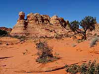
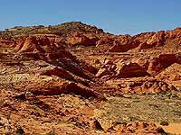
Cottonwood Area
(enlargeable)


Location: west of Page, Paria Canyon - Vermilion Cliffs Wilderness, northern Arizona
Driving Distance: about 54 miles from Page to the Cottonwood Cove Trailhead; about 277 miles from Phoenix to Page
Hike Time: all day
Direction to the Trailhead: From Page go west on US-89 (towards Kanab, UT) for about 30 miles, there make a left onto the unpaved access road, from there it is a 24 miles drive to the Cottonwood Cove Trailhead (you can find an exact description of the driving directions from the US-89 to the trailhead further down the page).


Soon after my hike to The Wave in the Coyote Buttes North, which are amazing, I wanted to explore the area of the Coyote Buttes South.

THE COTTONWOOD AREA

So I was searching for information again. I hit the 'jackpot' with the book 'Hiking and Exploring the Paria River' (3rd Edition) by Michael R. Kelsey - in which he describes not only the famous canyon of the Paria river but also writes about hiking in other areas of the Paria Canyon - Vermilion Cliffs Wilderness.
And I found interesting info and photos on the homepage of Karsten Rau (see the link @ my Link Collection), a German hiker and globetrotter, as well.

Cottonwood Plateau, Coyote Buttes South
Cottonwood Plateau, Coyote Buttes South (enlargeable)

With these informations and some beautiful pictures I had no problem to gain the attention from my reliable hiking buddy for a trip to the Coyote Buttes South.


All photos here on this page can be enlarged for better viewing - just click on a photo. To get back to this page, click the 'Left-Arrow/ Back Button' on the photo page or the 'Return Button' of your browser.

Please visit also the pages
Photo Collection 1.Tour
and 2.Tour with all
photos of both trips.

I knew the procedure for online permits on the Website of the BLM (Bureau of Land Management) already. So I had no problem to get the permits. Actually it is easier than the permits for the Coyote Buttes North (with the Wave) because the southern area is not as famous as the northern.
To get some information and tipps how to get a permit please visit my page Permit.

And soon we were on the way. Only two months after my hike to the Wave we were driving towards Page and the beautiful Lake Powell in northern Arizona.

As soon as possible we drove to the Paria Canyon Contact Station (between Page AZ and Kanab UT). The permits had not arrived yet. So I showed the copies of the online permit (reference number, payment,...) and we got the permits.

The Last Miles to Drive. To get to the Coyote Buttes South you use the same roads to the trailheads for the Wave.
From the Wire Pass Trailhead (main access point for hikes to the Wave) you continue to drive the House Rock Valley Road (BLM Rd. #700) south. Close to the Lone Tree Reservoir you make a left turn (east).

The adventure begins right after the Lone Tree TH. From here on it is not a simple dirt road anymore - it's more a driving path with some parts of deep sand. No question - this is 4WD (!) country for cars with high clearance.

Paw Hole Teepees
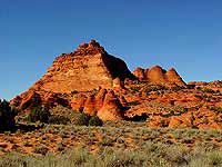
Paw Hole Teepees (enlargeable)

Next you will pass the Paw Hole Trailhead (the first 'real' trailhead for the Coyote Buttes South, southwest of the Paw Hole Teepees) and then close to the abandoned Poverty Flat Ranch (you will see the wind mill from a distance). Just before you get to the ranch you have to turn north towards the Cottonwood Cove Trailhead which is (at least in my opinion) the best access point for hikes in this area.
At the C.C. TH (some use this shortform for that trailhead) we could not find a sign but you can see the corral (which you can find on good maps) and the fence with a gate.

Tipps: Don't forget to leave the 'car portion' of the permit on the dash board before you start hiking.

There is another access point and trailhead farther north - the Cottonwood Spring TH. But I don't recommend to drive there. The driving path to this trailhead is really bad!

Time to drive from the US-89 to the Cottonwood Cove Trailhead: 1.5 - 2 hours. For detailed information and photos of the trailheads please visit my page Trailheads / Maps for the Coyote Buttes.

Note: You have to cross several deep ditches (washes). The road conditions change dramatically in or after rain. Then driving (even for 4WDs) will become extremely difficult if not impossible.
As you leave the House Rock Valley Road (near the Lone Tree TH) you are entering pure 4WD country (even in best weather)!


The Hike. There is no secret about trails or directions in the Coyote Buttes South cause there are no trails - it is open land to explore.
This area is not as known as the northern part for several reasons. First there are only 10 hikers a day (with permits) allowed. Second the rough drive to the better access points prevents many from getting there.
All we could find here were traces of boots in the sand from hikers of past days - not one car at the trailheads or on the 4WD road.

Even Rangers couldn't tell me a lot about this beautiful area. The best advice I got was to enter the Cottonwood Plateau from the norteast. From there the access should be easier. Well, it was at least a start.

We studied maps (Coyote Buttes & Poverty Flat, 7.5" USGS, 1:24.000) and used a compass for orientation. Which is very important in an open field without trails. It not only helps to get around but also to find the way back to the car.
We decided to hike up to the plateau first and then westwards to the Cottonwood Cove, a 'hidden' valley between the plateau and the Top Rock. And if there would be enough time we would hike to Cottonwood Spring, north of the Plateau.

Cottonwood area
In the center
of the Cottonwood area
(enlargeable)

Sandstone Formation, Cottonwood Plateau
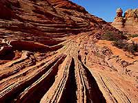
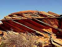
Sandstone Formation
(enlargeable)


But we should not get to the Cottonwood Spring. So many beautiful and amazing sandstone formations on the plateau and around the Cottonwood Teepees and the stunning view from higher ground into the lower Cottonwood Cove asked for time to enjoy and to take photos.
Here in front of pure beauty of nature the time seemed to stand still.

The Torch
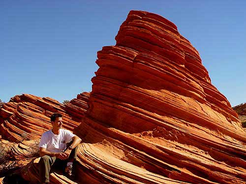
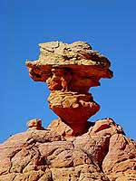
The Torch (enlargeable)
Some of the fantastic sandstone formations invited us not only to take a break but also inspired me to names for them.
For example The Torch - a several meters high structure, which upper part becomes more slim before the top of it opens up like a rose bud.
In respectful distance but close enough to detect the details I admired this unique object in golden and red colors. After a few minutes I visualized it as a natural lighthouse towering the plateau - The Torch.

But let's go back to the beginning of the hike.

From our trailhead we hiked up a hill along the 'road' towards the Cottonwood Spring TH first. From there you have a good view around.
Facing north you can see an impressive group of teepees to your right. To your left there is the elevated plateau surrounded by teepees - like a fortress. Here we left the road, explored the teepees first and then hiked up the plateau.

Here the beauty of this area opened up right in front of our eyes. Unique sandstone formations - some seem to defy gravity, others, like the 'brainrocks', ask you for deep thoughts (nomen est omen). You will see here many teepees in different shapes and colors too.
Respectful you make one footstep after the other to explore the plateau.

Cottonwood Plateau, Coyote Buttes South
Big 'brainrocks' reflect in a pond (filled by rain water)
on the Cottonwood Plateau (enlargeable)

After about 4 hours we reached the west rim of the plateau. There we found fascinating delicate formations like the several feet long Oyster. Is there a pearl hidden in there?
But the most exciting moment for me was the view into the Cottenwood Cove below. With many teepees in more than a dozend groups on different levels this valley nestles to the eastern part of the southern Top Rock.

The Oyster
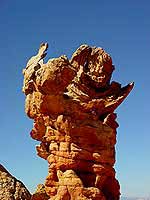
The Oyster
(enlargeable)

Cottonwood Cove
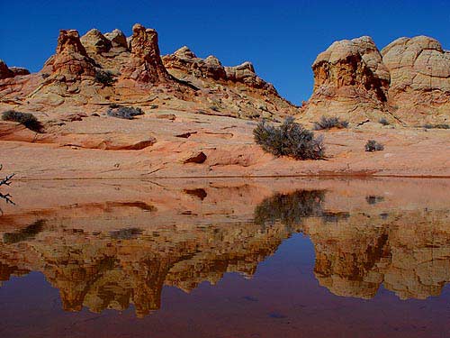
southern Cottonwood Cove
(enlargeable)


Several other discoveries (we climbed a little bit) let us only imagine the many treasures of nature in this area - an area of solitude and beauty.
Of course one single day is way to short for the Cottonwood area in the Coyote Buttes South.

Final Thoughts. The Wave in the northern part of the Coyote Buttes is probably the most significant place in the Paria Canyon - Vermilion Cliffs Wilderness but the variety and solitude of the Cottonwood area makes the southern part a nearly endless and spectacular hiking region.

1. & 2.Tour On the current page you can see some of the pictures of my 1.Tour. Less than a year later I went again to the Coyote Buttes South and the
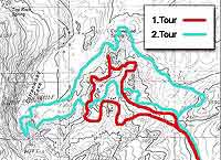
 incredible Cottonwood area.

Don't miss the 2.Tour which brought me on a long hiking day to even less known parts of the Cottonwood area. It was truly a discovery tour.

Click on the map to see an enlarged version of the Cottonwood area and the routes of my hiking tours. I did both hikes counter clock wise - first north, then west and finally east back to the parked car.

Note: You hike on your own risk. Be aware of your ability and your own responsibility. Ware appropriate clothing and shoes, and carry always more than enough water.
And ... LEAVE NO TRACE! Take everything (!) out you brought in or hasn't been in this beautiful part of nature before you arrived.


More pages about the Coyote Buttes South and hiking:
[Coyote Buttes South 2.Tour] [Photo Collection 1.Tour] [Photo Collection 2.Tour]
[Permit] [Weather] [Link Collection] [Trailheads / Maps]

[BACK]


send to printer


Website Orientation:
> Home/Welcome
  > EXTRA!!! my magazine
    > Trips & Hiking
      > Hiking in Northern Arizona
        > Paria Canyon - Vermilion Cliffs Wilderness
          > Coyote Buttes North & South
            > Cottonwood area, Coyote Buttes South (= you are here)

[Welcome]  [USA Austria]  [EXTRA - my magazine]  [Webcam Links]  [Link Collection]
[About me]  [Photo Collections]  [Downloads]  [Disclaimer]  [Sitemap]  [Guestbook]  [Email]

back to top back to previous page Home - www.gbintheworld.com If you didn't get to this page through the mainpage ('choose a language')
of gbintheworld.com then please click here!!!

© gbintheworld


Datenschutzerklärung